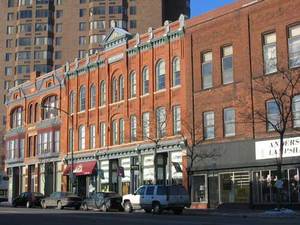
 This weeks Featured Neighborhood – The West 7th area
Map St. Paul District council 9, Fort Road Federation
The West 7th neighborhood is one of the oldest in the twin cities. West 7Th street runs from old Fort Snelling, to downtown St. Paul, and runs along the Mississippi River. It is also called Fort Road and in the early 1800’s was a wagon trail. The oldest homes in St. Paul are located in the area. Part of the neighborhood is the Irvine Park historic district.
Housing style include Victorian, Queen Anne, Italianate, Greek Rival and some ramblers and even split levels. Here is a link to pictures of homes, including my own in the upper town neighborhood near the Smith avenue high bridge. The area has changed quite a bit in over the last 25 years and homes have appreciated at a rapid rate. There is new housing along the river and the largest development in the history of the city of St. Paul, Victoria Park, is being built on West 7th and Otto.
In 2005 the average price of a home in the neighborhood according to the regional multiple listing service was $180K. The average for the city that same year was $196.500.
Click to see what is currently on the market in the neighborhood. Also see census data compiled by the wilder foundation.
